RECAP
What: Bike Tour (Semi Inclusive), Classic Alp Climbs, including several iconic climbs of the Tour de France
Where: Savoie, Haute-Savoie Region, France
Length of Trip: 6 days, 5 nights
Hotel/Lodging (Incl.): Hotel Beauregard, Chamois d’ Or
Meals Included: Daily Breakfast, 2 Lunches, 3 Dinners
Number of Guests: 14 (10 Male riders, 4 Female riders)
Nationality of Guest(s): 13 US Citizens, 1 Australian
Approximate Age Range of Guest(s): 30 – 69 yrs. young
Number of Tour Guides: 2
Support Van: 1
Tour Company: Trek Travel
Bike Information/Bikes Provided on Tour: Trek Domane SL 7 Carbon Road Bike, equipped with Di2 electronic shifting, 50/34 Compact, 11-32 rear cassette, Bontrager Paradigm Comp Wheels (optional upgrade to Aeolus D3 carbon wheels for $200), Bontrager saddle, Shimano pedals (clipless, road, flat and/or caged). Note: riders, at their discretion could bring their own pedals and saddles and our guides would install during bike fitting/inspection.
Bike Accessories per Rider (Incl.): Garmin Edge 1030 (pre-programmed with our daily routes), 2 Trek water bottles, a flat pack, front and rear flare lights, and a Trek Travel bike jersey and swag bike. Snacks and drinks for each day’s ride.
Note: All mileage, gradients, and elevation gains provided below are approximate.
—————————
DAY 1
I met my fellow cyclists on July 29, at 9:00 a.m., in front of the Annecy Train Station. From there, we took a short drive by shuttle bus to arrive at our bike-fitting rendezvous location in Menthon-Saint-Bernard.
Brief introductions and a safety session were held over coffee and pastries. Thereafter, each rider was fitted to their Trek Domane SL 7.
A briefing of the Garmin Edge 1030 followed, and then, we were off on our bike adventure. Our ride started with an easy warmup along lake Annecy before heading out of town into the alpine hills to tackle Col du Marais and Col de la Croix Fry.
From St. Ferreol, we exited onto Route des Esserieux to begin our climb up Col du Marais. The climb is 6.5 miles long with an elevation gain of 1,213 +/- ft. The average gradient is 4.5%; the maximum gradient is 7.5%.
After conquering Col du Marais, we attacked Col de la Croix Fry. Tour de France watchers may recall that the Col de la Croix Fry was featured in Stage 10 of this year’s Tour de France. The ascent is roughly 8 miles long with an elevation gain of 2,755 +/- ft. The average gradient is 6.6 %. After Manigod, there are a few spots around 10%; thereafter, the gradient lowers between 6%-8% before reaching the cafe at the summit.
After lunch at the cafe, we were rewarded with a short but sweet descent, followed by a few more uphill climbs into the ski resort village of La Clusaz, our home base for the next two days.
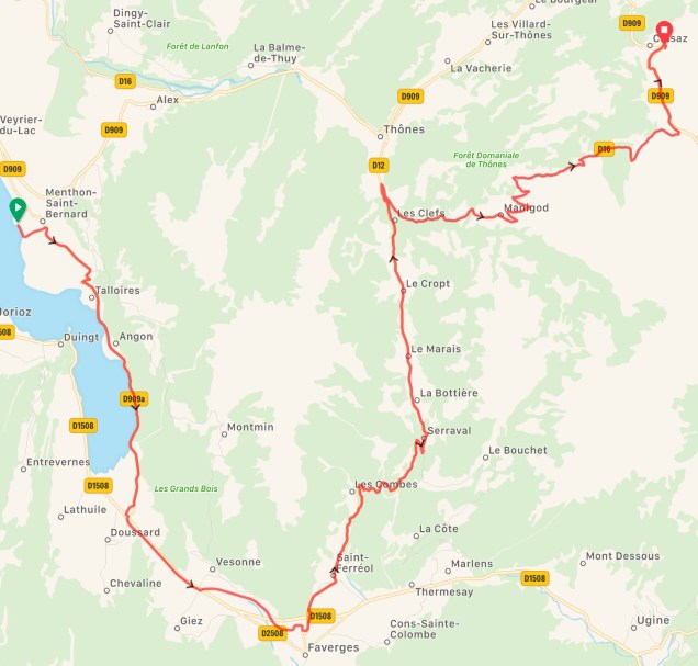
Map of Ride, Day 1 – 34 miles and 5,023 +/- ft. of climbing.
DAY 2
After breakfast, we met our guides for a quick briefing and pre-ride prep. From our hotel, we cruised out of town to conquer Col des Aravis, Megeve, Sallanches, and Col de la Colombiere.
First, we tackled Col des Aravis. From La Clusaz, the climb is slightly over 4.5 miles long with an elevation gain of 1,345 +/- ft. The average gradient is 5.8%; the maximum gradient is 9.5%. This famous mountain pass has been used some 40 times in the Tour de France. It was last used in 2016. At the top of the pass, on a clear day, riders can get a great view of the Mont Blanc Massif. After climbing Col de Aravis, we biked through the towns of Megeve and Sallanches before tackling Col de Colombiere. The ascent is slightly over 10 miles long with an elevation gain of 3,635 +/- ft. The gradient averages 6.8% to a maximum 10% near the top. Once over the finish line, I hopped off my bike to relax. Time to enjoy the views and breezes from the summit. I joined several co-riders for lunch, drinks and/or ice cream at the summit restaurant (seated and shaded under outdoor umbrellas). Afterwards, we experienced a fast, fun descent, and pedaled our way back to La Clusaz.
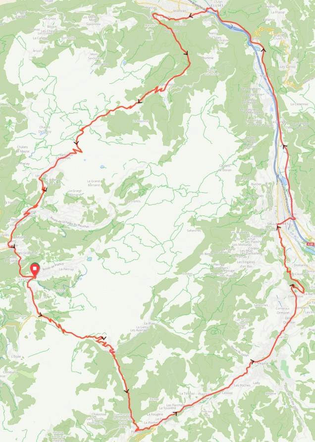
Map of Ride, Day 2 – 60 miles and 7,531 +/- ft. of climbing
DAY 3
After breakfast, we met for our usual briefing and pre-ride prep. Today’s route: Col du Marais, Col de l’Arpettaz, and Col des Aravis.
From Thônes, Col du Marais is just over 4 miles long with a average gradient of 3.5% and a maximum gradient of 7% for roughly 1,312 +/- ft.
Next, we tackled l’Arpettaz (Ugine). We climbed roughly 7.5 miles with an average gradient of 6% before cruising into the village of Flumet.
From Flumet, we ascended Col de Aravis. The climb is slightly over 7 miles long, ascending 1,889 +/- ft. The average gradient is 5%, but from the village of La Giettaz, the gradient will fluctuate between 6%-8% towards the summit with a short section topping out at 11.8% before declining to around 3.5%.
In addition to our climbs, we enjoyed several fun descents and a lovely ride along a paved, flat bike path.
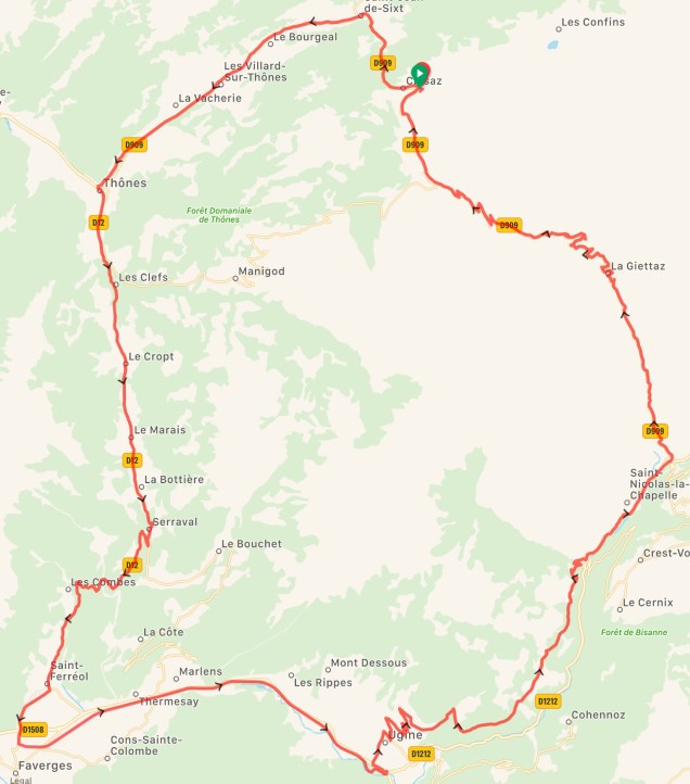
Map of Ride, Day 3 – 50 miles and 5,837 +/- ft. of climbing
DAY 4
After breakfast, we began our 1.5 hour shuttle ride from La Clusaz to La Chambre. Today’s ride would encompass the mountain passes of Col du Glandon, Col de Croix de Fer, and Col de la Confession.
After a quick briefing and pre-ride prep in La Chambre, we headed out to tackle Col du Glandon. This high mountain pass is roughly 13 miles long with an elevation gain of 4,862 +/- ft. The average gradient is 7.5%, but there is a maximum gradient of 11%, in the switchbacks just before the top. This giant climb has been featured in the Tour de France some 13 times, most recently in 2015. Col de Croix de Fer is less than 2 miles uphill from the top of Col du Glandon, making the total ascent 5,348 +/- ft. from La Chambre. The elevation at the top of Col de Croix de Fer is 6,781 ft. Afterwards, we enjoyed a long sweeping descent to our lunch destination, Creperie Les Favets. We finished lunch around 4:00 p.m. With daylight fading, only five of our fastest riders braved both Col de Confession and the last six switchbacks of the traditional Alpe d’ Huez.
Col de Confession is a scenic mountain pass that connects to the village of Alpe d’Huez. Starting at Villard-Reculas, the ascent is 3,953 +/- ft. in 13.55 miles with an average gradient of 6% and a maximum gradient of 9%. There is a short downhill reprieve before entering the village of Alpe d’ Huez and completing the last six switchbacks of the traditional Alpe d’ Huez ride.
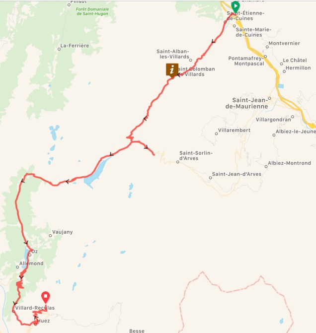
Map of Ride, Day 4 – 45 miles and 10,042 +/- ft. of climbing
DAY 5
Alpe d’ Huez via Col de Sarenne.
Col de Sarrene is a lovely mountain pass linking Alpe d’ Huez with the village of Mizoen and La Freney-d’Oisansin in the Romanche Valley. Several miles into the ride, there is a long, steep descent on gravel road accompanied by sharp hairpin turns and a few sections of narrow roadway shared simultaneously with cars coming from the opposite direction. The steep drops, if you can muster them, are worth the views. Once downhill, we cruised across a dam, through several traffic tunnels, while taking in the stunning views of the waterways, mountains, gorges, and valley before arriving at the base of Alpe d’ Huez to begin our iconic climb up the infamous 21 switchbacks.
From the village of Le Bourg d’ Oisans, the road ascends 8.55 miles, 3,280 +/- ft., with an average gradient of 8.1% and a maximum gradient of 13% in a few spots. Each of the 21 switchbacks are named after a rider who has won a Tour de France stage.
Our guide(s) met each of us with cheers and a champagne toast as we crossed the official Tour de France finish line at the top of Alpe d’ Huez.
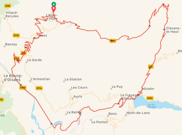
Map of Ride, Day 5 – 31 miles and 5,513 +/- ft. of climbing
DAY 6
Alpe d’ Huez to Alpine Lake.
A short ride for cyclists wanting to take photos and/or experience one more day of the alpine lakes, mountains and glaciers from behind the village of Alpe d’ Huez.
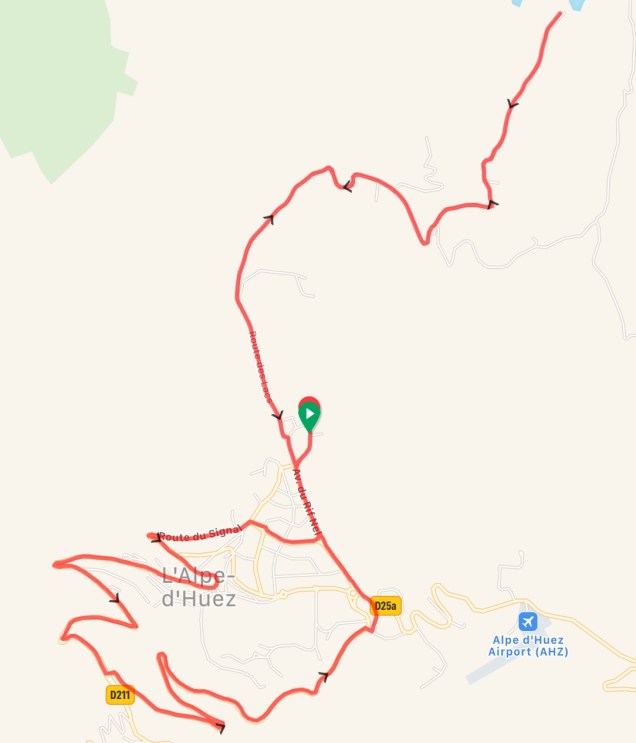
Map of Ride, Day 6 – 10 miles and 1,752 +/- ft. of climbing
PROS OF TOUR TRIP
- Great way to see a new region of the world on bike, particularly if you have never been to the area before;
- Pre-programmed, user friendly, navigable bike routes via the Garmin Edge 1030;
- Access to help and support via the expertise of guides that know the local area, and who are experienced and/or skilled cyclists;
- Access to high quality road bikes well suited for the local terrain;
- Great food;
- Terrific lodging accommodations;
- Great way to meet other like-minded cyclists; and
- Great commaderie between the group members/cyclists and guides.
CONS OF TOUR TRIP
- Weather is extremely variable (note: during our week of riding, the region experienced an unprecedented heat wave with temperatures in the high 80’s and 90’s with ocassional high humidity);
- Bike routes are pre-determined. Some routes offer shade from the elements, other routes offer minimal to no shade;
- Most rides started between 8:30 a.m. – 9:30 a.m. , a few started after 10:00 a.m.;
- Not all cyclists will traverse all routes at the same pace, the support van can only be in one place at one time; and,
- In the event of rain, certain portions of the bike route(s) may be altered and/or cancelled (think, steep descents).
Overall Trip Rating: